« Punta de Mazaltàn » : différence entre les versions
Aller à la navigation
Aller à la recherche
Aucun résumé des modifications |
Aucun résumé des modifications |
||
| (11 versions intermédiaires par le même utilisateur non affichées) | |||
| Ligne 1 : | Ligne 1 : | ||
{{Infobox Ville | {{Infobox Ville | ||
| Style = Duhnvehnahi | |||
| Nom = Punta de Mazaltàn | | Nom = Punta de Mazaltàn | ||
| Lien image = | | Lien image = Couverture wiki.png | ||
| Légende image = | | Légende image = | ||
<!-- Administration --> | <!-- Administration --> | ||
| Pays = | | Pays = {{Duhnveh'nahï}} | ||
| Nom_subdiv_1 = | | Nom_subdiv_1 = | ||
| Subdiv_1 = | | Subdiv_1 = | ||
| Ligne 11 : | Ligne 12 : | ||
| Maire = | | Maire = | ||
| Mandat = | | Mandat = | ||
| CGETM = | | CGETM = 1101001 | ||
<!-- Démographie --> | <!-- Démographie --> | ||
| Gentilé = | | Gentilé = Mazaltais, mazaltaise | ||
| Population = | | Population = 511 318 | ||
| Date population = | | Date population = 1818 | ||
| Densité = | | Densité = | ||
| Population agglomération = | | Population agglomération = 789 198 | ||
| Date population agglomération = | | Date population agglomération = 1818 | ||
<!-- Géographie --> | <!-- Géographie --> | ||
| Superficie = | | Superficie = | ||
| Ligne 29 : | Ligne 30 : | ||
| Disparition = | | Disparition = | ||
<!-- Localisation --> | <!-- Localisation --> | ||
| Map = | | Map = Localisation Punta de Mazaltàn low.png | ||
}} | }} | ||
== Toponymie == | |||
== Géographie == | |||
=== Localisation === | |||
{{Limitrophe | |||
| type = Commune | |||
| nom = Punta de Mazaltàn | |||
| élision = | |||
| notes = | |||
| nord = | |||
| nord-est = | |||
| est = | |||
| sud-est = | |||
| sud = | |||
| sud-ouest = | |||
| ouest = | |||
| nord-ouest = | |||
| enclave = | |||
| width = | |||
| align = | |||
}} | |||
=== Relief et hydrographie === | |||
=== Climat === | |||
== Urbanisme == | |||
<div style="text-align : center;">[[Fichier:Photo-non-disponible.jpg|750px]]<br>''<small>Carte de la commune de</small>''</div> | |||
=== Morphologie urbaine === | |||
=== Quartiers === | |||
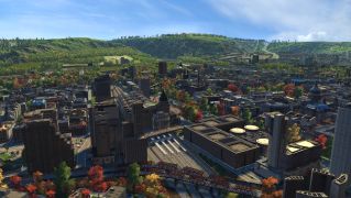
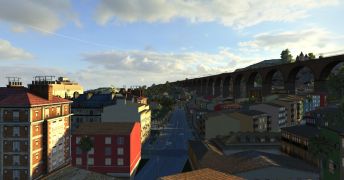
==== Punta de Mazaltàn ==== | |||
<gallery mode="packed" heights="150px"> | |||
File:Gamescreen0169.jpg| | |||
File:Gamescreen0614.jpg| | |||
File:Gamescreen0150.jpg| | |||
</gallery> | |||
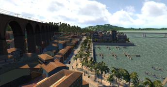
==== Punta Cuidakoro ==== | |||
<gallery mode="packed" heights="150px"> | |||
File:Gamescreen0212.jpg| | |||
File:Gamescreen0010.jpg| | |||
File:Gamescreen0224.jpg| | |||
</gallery> | |||
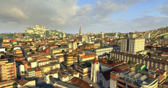
==== Punta Venezia ==== | |||
<gallery mode="packed" heights="150px"> | |||
File:Gamescreen0003.jpg| | |||
File:Gamescreen0777.jpg| | |||
File:Gamescreen0004.jpg| | |||
</gallery> | |||
==== Punta Anskhelà ==== | |||
<gallery mode="packed" heights="150px"> | |||
File:Gamescreen0245.jpg| | |||
File:Gamescreen0211.jpg| | |||
File:Gamescreen0246.jpg| | |||
</gallery> | |||
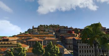
==== Punta Bakhanah ==== | |||
<gallery mode="packed" heights="150px"> | |||
File:Gamescreen0095.jpg| | |||
File:Gamescreen0094.jpg| | |||
</gallery> | |||
[[Catégorie : Punta de Mazaltàn]] | |||
== Transports == | |||
=== Réseau de transports urbain === | |||
=== Transport ferroviaire === | |||
==== Gares ==== | |||
'''Punta Centrales'''<br> | |||
<gallery mode="packed" heights="150px"> | |||
File:Gamescreen0594.jpg| | |||
File:Gamescreen0235.jpg| | |||
File:Gamescreen0195.jpg| | |||
</gallery> | |||
==== Réseau inter-urbain ==== | |||
==== Réseau national ==== | |||
=== Transport aérien === | |||
=== Ports et connexions maritimes === | |||
== Economie == | |||
== Histoire == | |||
== Politique et administration == | |||
=== Elections municipales === | |||
==== Liste des Maires ==== | |||
{| class="wikitable" | |||
|+ Texte de la légende | |||
|- | |||
! Photo !! Nom Prénom !! Mandat !! Tendance politique | |||
|- | |||
| || || [[Election municipales de 1815|1815-1821]] || | |||
|- | |||
| || || [[Election municipales de 1821|1821-1827]] || | |||
|} | |||
=== Autres élections === | |||
=== Jumelages === | |||
== Démographie == | |||
== Education == | |||
== Sports == | |||
== Culture et patrimoine == | |||
=== Monuments === | |||
=== Personnalités liées à la commune === | |||
=== Héraldique et devise === | |||
{| | |||
|- | |||
| width = 15% | [[Fichier:Armoirie Punta de Mazaltàn.png|200px|sans_cadre]] || width = 85% | '''Armoiries de la ville de Punta de Mazaltàn''' | |||
|} | |||
== Galerie == | |||
<gallery mode="packed-hover" > | |||
Fichier:Gamescreen0026.jpg|Punta Cuidakoro | |||
Fichier:Gamescreen0229.jpg|Punta Cuidakoro | |||
Fichier:Gamescreen0071.jpg|Punta de Mazaltàn | |||
Fichier:Gamescreen0080.jpg|Citadelle de Punta de Mazaltàn | |||
Fichier:Gamescreen0241.jpg|Punta Anskhelà | |||
Fichier:Gamescreen0247.jpg|Punta Anskhelà | |||
</gallery> | |||
== Notes et références == | |||
=== Articles connexes === | |||
=== Notes et inspirations === | |||
=== Références === | |||
<references /> | |||
[[Catégorie:Villes du Duhnveh'nahï]] | [[Catégorie:Villes du Duhnveh'nahï]] | ||
Dernière version du 5 mars 2026 à 12:38
| Punta de Mazaltàn | |
|---|---|

| |
| Administration | |
| Pays | |
| Maire | |
| Mandat | |
| Code CGETM | 1101001 |
| Démographie | |
| Gentilé | Mazaltais, mazaltaise |
| Population | 511 318 hab. (1818) |
| Densité | hab/km² |
| Population agglomération | 789 198 hab. (1818) |
| Géographie | |
| Superficie | km² |
| Autres | |
| Localisation | |

| |
Toponymie
Géographie
Localisation

Relief et hydrographie
Climat
Urbanisme

Carte de la commune de
Morphologie urbaine
Quartiers
Punta de Mazaltàn


Punta Cuidakoro


Punta Venezia


Punta Anskhelà


Punta Bakhanah


Transports
Réseau de transports urbain
Transport ferroviaire
Gares
Punta Centrales


Réseau inter-urbain
Réseau national
Transport aérien
Ports et connexions maritimes
Economie
Histoire
Politique et administration
Elections municipales
Liste des Maires
| Photo | Nom Prénom | Mandat | Tendance politique |
|---|---|---|---|
| 1815-1821 | |||
| 1821-1827 |
Autres élections
Jumelages
Démographie
Education
Sports
Culture et patrimoine
Monuments
Personnalités liées à la commune
Héraldique et devise
 |
Armoiries de la ville de Punta de Mazaltàn |
Galerie
-
 Punta Cuidakoro
 -
 Punta Cuidakoro
 -
 Punta de Mazaltàn
 -
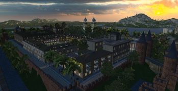 Citadelle de Punta de Mazaltàn
 -
 Punta Anskhelà
 -
 Punta Anskhelà


